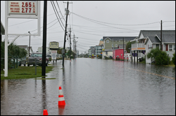
A flooded street, September 30, 2010 in New Hanover County, NC. (Courtesy Island Gazette)
|
HMT-SE Discussion of High-Impact Storm
Forecasters and researchers representing NOAA-ESRL, the NWS, and several North Carolina-based universities met via GoTo Meeting on 15 October 2010 to review the high-impact precipitation event that affected portions of the southeast US during the week of Sept 26 – Oct 1, 2010. The rainfall came in two periods, and the combination of the precipitation events caused flooding across the region as well as multiple fatalities. Most notably, Wilmington, NC received over 22 inches of rain and set an all-time 5-day precipitation record (a "500-year event"), which exceeded the rainfall totals produced by Hurricane Floyd in 1999.
Unique forecast challenges shared by several NWS offices in the region included the two-part nature of the event, accuracy concerns with real-time quantitative precipitation estimates and forecasts, and the location and number of stream gauges available for real-time streamflow measurements. The information shared between researchers and forecasters was also of benefit to HMT-SE planning, as the meeting provided valuable operational and research-focused insights on a recent high-impact event occurring in the geographical region of primary concern for the HMT-SE project. Next steps may involve using numerical models to investigate the role of specific precipitation processes that contributed to the extreme nature of the event, as well as comparing aspects of this event to other relevant cases across the region.