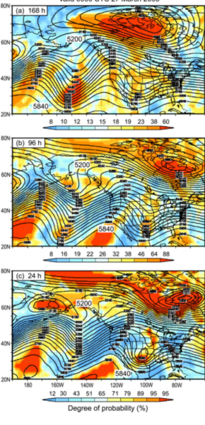
Fig. 13 from the paper: GFS ensemble mean forecasts of 500-hPa geopotential heights (40-m contour interval) valid at 0000 UTC 27 Mar 2005, based on the following forecast leads: (a) 168, (b) 96, and (c) 24 h. The colors denote the degree of probability of verification.
|
HMT Publication Notice
HMT-West has identified atmospheric rivers (ARs) as a major cause of extreme precipitation in the west coast region of the U.S. This paper elucidates key physical processes that came together to generate up to 200 mm of rain in roughly 2 days in Oregon, including the role of the MJO, as well as entrainment of tropical water vapor (i.e., a "tropical tap") and the contribution of a mesoscale frontal wave to extending the duration of AR conditions over the watersheds that experienced the heaviest rain. The paper also illustrates uncertainties in the forecast of this event by GFS from 1-14 days in advance. Of particular interest is the fact that the region of the AR was characterized by large forecast uncertainty just 2-4 days before landfall in the Pacific Northwest. These findings helped shape the recent Winter Storms and Pacific Atmospheric Rivers (WISPAR) experiment that flew the NASA Global Hawk aircraft using a new automated dropsonde system to sample the tropical tap region of an AR northeast of Hawaii in February 2011. The results have also defined a new research direction associated with distinguishing the location of maximum duration of AR conditions during a storm through the effects of mesoscale frontal waves. The longer an AR stays focused on a particular region increases the risk that region will experience substantial flooding.