Figures:
Correlation between Q2 radar-estimated precipitation and IRFREQ, original CMORPH, and KF CMORPH, plotted as a function of local time.
Correlation between Q2 radar-estimated precipitation and IRFREQ (red), original CMORPH (black), and KF CMORPH (green), plotted as a function of local time (x-axis). Comparisons are for 0.25o lat/lon 30-min precipitation rates over CONUS for July-August 2009. Results for CMORPH with 9-, 7-, 4-, 2-, and 1-satellite configurations are plotted in panels a)-e), respectively.
Example of a PSD soil science station. This particular installation is in the Sierra foothills at O'Neals, California.
Distribution of daily precipitation for August 2, 2007, derived from gauge-based analysis (top-left), CMORPH satellite estimates (top-right), bias-corrected CMORPH (bottom-left), and combination of gauge analysis and bias-corrected CMORPH (bottom-right).
Click images for more detail
Contact:  Pingping Xie
June 24, 2011

New Techniques to Integrate Precipitation Information from Multiple Sources

A suite of new techniques are being developed at NOAA's Climate Prediction Center to construct high-quality, high-resolution, global, and regional precipitation analyses by integrating information from multiple sources including gauge measurements, radar observations, satellite estimates, and numerical model simulations. Jointly supported by HMT and the NOAA Climate Program Office, this project is being carried out as part of NOAA's contribution to the Global Precipitation Measurement mission.

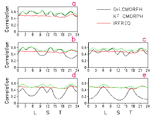
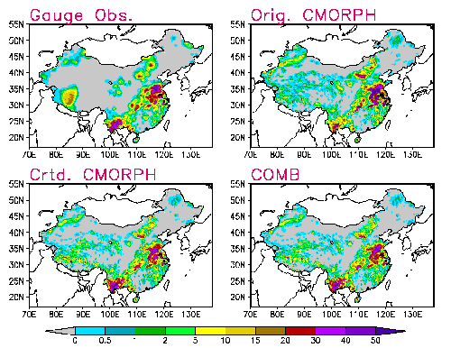
The integration of precipitation information is conducted in two sequential steps. First, satellite-based high-resolution precipitation estimates are constructed by combining information from observations from all available geostationary and low earth orbit satellites. This process utilizes a Kalman filter based integration framework referred to as CMORPH (CPC Morphing technique). Second, the satellite-based estimates are merged with gauge measurements, radar observations, and other information to produce regional precipitation analyses with refined quantitative accuracy and time / space resolution. A prototype model has been developed to combine the satellite estimates with gauge observations using test data over China.

Further work is underway to develop these techniques into an operational system capable of generating high-quality, high-resolution, precipitation analyses for improved applications in weather, climate, and hydrometeorology.


Related Publications

Joyce, R. J., and P. Xie, 2011: Kalman Filter based CMORPH. Accepted for publication at J. Hydrometeor.
Xie, P., and A.-Y. Xiong, 2011: A conceptual model for constructing high-resolution gauge – satellite merged precipitation analyses. Submitted to J. Geophy.Res.
404 Not Found

404 Not Found


nginx/1.25.5