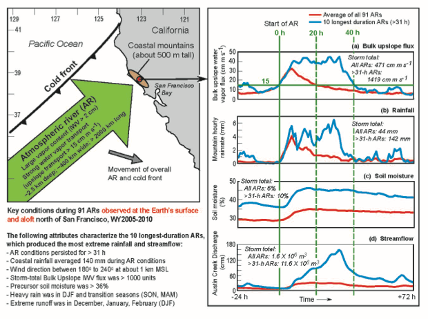
Figure from Ralph et al. 2012. Schematic summary of atmospheric and hydrometeorological conditions associated with land-falling atmospheric rivers recorded by an atmospheric river observatory (ARO) at Bodega Bay, California, and additional observations from nearby. (left side) Plan view (based on previous studies summarized in the Introduction) of an AR striking the coast ahead of a cold front (see Fig. 1a for an example). Note that the storm systems tend to move from roughly west to east across the observing site (red dot), with winds blowing from southwest to northeast. (right side) Composite time series traces comparing the 10 longest-lasting ARs (in terms of time affecting the field site) versus the composite of all 91 cases. The 10 ARs that lasted longest over the field site averaged twice as long (40 h) as the average AR event (20 h). The solid (dashed) vertical green lines mark the start time (end times) of composite AR conditions. The horizontal green line in the top time-series trace shows the upslope IWV flux threshold (i.e., 15 cm m s-1) for AR conditions.
Figure from paper. Click for more detail.
|
|
|
November 30, 2012
HMT Publication Notice
A journal article, Observed impacts of duration and seasonality of
atmospheric-river landfalls on soil moisture and runoff in coastal northern California,
by Ralph, F. M., T. Coleman, P.J. Neiman, R. Zamora, and M. D.
Dettinger is in press at the Journal of Hydrometeorolgy. It is part of
the special collection on "State of the Science Precipitation Research."
This paper addresses one of HMT's Major Activity Areas - Quantitative
Precipitation Forecasting (QPF) by evaluating the role of the duration of
atmospheric river conditions at a field site where the NOAA/ESRL
Physical Sciences Division has
operated a wind profiler, GPS-met receiver and other sensors as an
atmospheric river observatory (ARO) for several years. The results provide
insight into the importance of monitoring the start and end time of AR
conditions and the time-integrated "storm-total" upslope water vapor flux
using an observable proxy measure referred to as the "bulk flux." These
results were used to help design a forecasting experiment conducted at
NCEP/HPC in September 2012. They also highlight the importance of
long-term observations without which these results would not have been
possible. This study builds on past work stimulated by HMT on
atmospheric rivers that identified their key role in extreme events.