A New Snow-Level Radar in Southern California Serves Dual Purposes
March 15, 2013
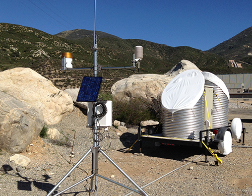
As part of the California Department of Water Resources/NOAA's HMT-Legacy Project, a new Snow-Level Radar (SLR) was deployed this week at the Devil's Canyon Power Plant in the San Bernardino Mountains of southern California.
Constructed from 1969 to 1974, the power plant was designed to meet the ever increasing demands for water and electricity in the region. Two pipelines carry water from Silverwood Lake, almost 1500 feet in elevation above the power plant, down to four Pelton wheel turbines, which generate enough electricity to accommodate both the communities of San Bernardino and Riverside. Silverwood Lake is situated at 3,350 feet, the highest elevation of any reservoir in the California State Water Project. When precipitation occurs, the SLR will document how much elevation in the San Bernardino Mountains is exposed to rain versus snow, which is critical for assessing potential flood risks. Higher snow levels expose more of the watershed to rain and increase the amount of surface water runoff, impacting reservoir storage (see article by White et al. 2010).
Information provided by the SLR is also critical to the region's transportation and commerce. Near the SLR site is Cajon Pass (elevation 3,777 feet), a mountain pass between the San Bernardino Mountains and the San Gabriel Mountains. Cajon Pass is also at the head of Horsethief Canyon, traversed by California State Route 138 and railroad tracks owned by BNSF Railway and Union Pacific Railroad. Interstate 15 does not traverse Cajon Pass, but rather the nearby Cajon Summit (elevation 4,190 feet). Forecasting the snow level for these critical thoroughfares is a primary challenge for forecasters in the National Weather Service's (NWS) San Diego Weather Forecast Office. The SLR will allow for verification of snow-level forecasts and could help with the issuance or cancelation of winter weather advisories and warnings.
The SLR provides measurements of the snow level in precipitation every ten minutes. Data are transmitted hourly to a data hub at the Physical Sciences Division and display products are generated almost immediately and posted on the internet. The Devil's Canyon SLR deployment is the eighth out of ten deployments that are part of the HMT-Legacy Project.
Contact: Allen White