Study highlights difference in observed snow level between coastal and inland Washington
April 4, 2016
The snow level (the level in the atmosphere where snow changes into rain) is an important variable in mountain hydrology because it determines the area of a watershed that will be exposed to rain versus snow, which ultimately impacts runoff and the potential for flooding. A recent HMT publication highlighted the difference in the observed snow level between coastal and inland locations in Western Washington and evaluated the performance of snow-level forecasts made by the National Weather Service (NWS).
HMT operated two vertically pointing S-band precipitation profiling radars (S-PROFs) at Westport (coastal) and Ravensdale (inland) in Western Washington for two winter seasons. Similar snow-level characteristics existed at both sites, although the inland site exhibited lower snow levels by ~70 m due to proximity to cold continental air, and snow-level altitude changes were delayed there by several hours owing to onshore translation of weather systems. The largest precipitation accumulations and rates occurred when the snow level was largely higher than the adjacent terrain, highlighting how warmer storms can create flooding. A comparison of these observations with long-term operational radiosonde data reveal that the snow levels measured by the S-PROFs mirrored climatological conditions.
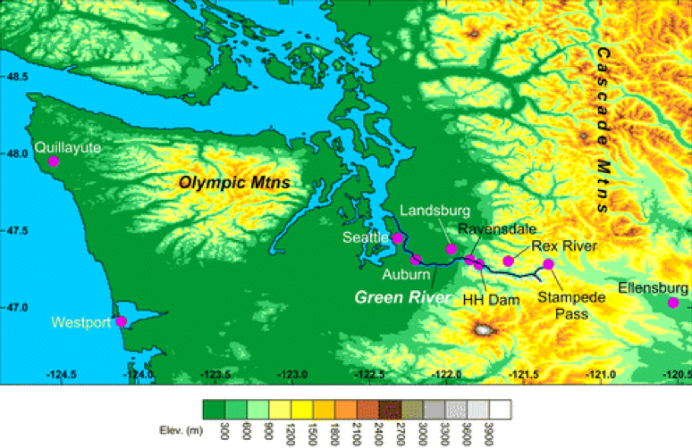
The inland S-PROF data were used to assess the performance of nearby operational snow-level forecasts produced by the NWS Northwest River Forecast Center for the upper elevations of the Green River watershed along the windward slope of Washington’s Cascade Mountains. The forecasts were lower than the observed snow levels by 100-250 m due to a combination of forecast error and imperfect representativeness between the forecast and observation location. These forecast discrepancies increased in magnitude with increasingly higher observed snow levels, thus representing the hydrologically impactful situations where a greater fraction of mountain basins receive rain rather than snow and generate more runoff than anticipated.
HMT no longer operates S-PROFs in Western Washington. However, in 2015 with funding from the Department of Energy, HMT installed three Doppler wind profilers in Western Oregon and Washington that are also adept at measuring the snow level, in addition to providing wind profile observations that are key to improving wind energy forecasts. These three Pacific Northwest wind profilers complement a similar network of coastal wind profilers being installed along the California coast with funding provided by the California Department of Water Resources.
Contact: Paul Neiman