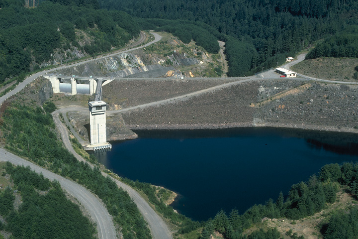
Howard Hanson Dam
|
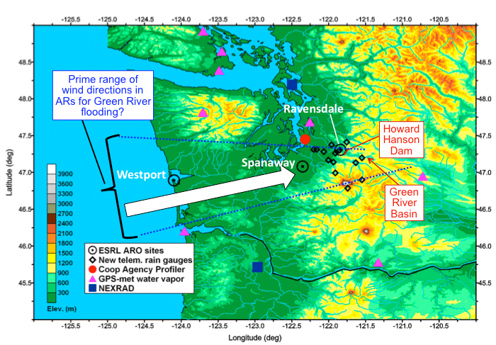
Map of Western WA showing locations ARO deployments, new NWS rain gauges, & other operational observing systems. Also shown is the prime range of wind directions in ARs that could possibly produce flooding along the Green River because these wind directions are not blocked by major features in the terrain.
|
HMT Advances Played a Key Role in NOAA's Response to the Howard Hanson Dam Flood Control Crisis
The Howard Hanson Dam has brought necessary flood relief to Washington's Green River Valley for more than four decades, and opened the way for increased valley development near Seattle. However, following a record high level of water behind the dam in January 2009, and the subsequent discovery of a leak, the U.S. Army Corps of Engineers (USACE) became concerned about the Dam's safety. Just one large winter storm could put the communities downstream at risk. NOAA's Earth System Research Laboratory (ESRL) and Office of Hydrologic Development (OHD) responded to the crisis.
ESRL deployed a mobile atmospheric river observatory (ARO) on the Washington coast and an ARO couplet closer to the dam, and displayed the data on a publicly-accessible web page. Special HMT-West weather model runs were expanded to cover the Pacific Northwest to provide the necessary model input for the ARO water vapor flux tool. ESRL also installed an ALPS workstation at the National Weather Service (NWS) Seattle Weather Forecast Office (WFO) to make the model runs and other HMT products available. The ALPS workstation allowed the weather model output and data products to be displayed in a format similar to what currently exists in the WFOs.
OHD added real-time data from 14 rain gauges located in and around the Green River Basin. The data from these gauges were used to refine NWS river forecast models and to determine a more accurate estimate of precipitation that fell across the basin during each storm. In addition, the Seattle WFO produced customized daily forecasts, including longer lead-time hydrologic outlooks, and new decision support services tailored for emergency managers and the public.
The ARO data were well received by Seattle WFO staff, who accessed data products on the ESRL data web page more than 2,200 times during the winter season. WFO staff also wrote about one or more of the data products in 50 separate twice-daily forecast discussions (a standard text product produced by the NWS).
Larry Schick, a meteorologist with the USACE, also used the ARO data to make a key water management decision. "We were right on the edge of taking over Wynoochee Dam today for flood control," he said. "But we had high confidence we didn't need to with the ARO info that the rain would taper off quickly – and it did."
The additional forecasts and decision support services provided by the Seattle WFO were highly regarded by many interested parties. "NWS developed and implemented a pilot project to provide the 3-5 day notification system for key/critical personnel to assist with decision making at the local and state level," said Jim Mullen, Washington State Director of Emergency Management. "It has been recognized that NWS set aside its discomfort in order to provide the maximum service that they could to local and state government response personnel and decision makers."
Effectively, HMT-West has now expanded the area it is working geographically, and the range of partners engaged in the use and evaluation of state-of-the-art observations, weather forecast models, display systems, and decision support tools. Key to the success of this project was the willingness of the Seattle WFO staff to use and evaluate these new HMT products and tools and provide enhanced weather forecast and decision support services to a variety of end users. "This work represents the very best of what can happen when we all work together collaboratively with our partners," said Dr. Dennis Hunsinger, Acting Regional Administrator of FEMA.