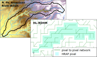
Hydrology Laboratory-Research Distributed Hydrologic Model (HL-RDHM) of the N. Fork of American River
|
|
Contact: Chengmin Hsu
|
Distributed Hydrology Model Installed at NOAA Earth System Research Laboratory
The hydrologic model being implemented is the Hydrology Laboratory-Research Distributed Hydrologic Model (HL-RDHM) which has been developed by the NWS Office of Hydrologic Development (OHD). HL-RDHM integrates algorithms for tracking incident precipitation, soil moisture, snow melt, evapo-transpiration and surface runoff. When applied to a watershed using a gridded data structure there are routines for accumulating the overland flows and routing through the channel network. In contrast to the traditional "lumped" approach, an advantage of the distributed approach is that channel flow estimates are available at any location in the watershed stream network.
To date, the HL-RDHM has been applied to the N. Fork American River basin to assess the quality of alternate HMT-QPE products and the influence of snow level as radar-detected bright band height (BBH) on streamflows. Through continued OHD collaboration WCB intends to extend the NFARB distributed model to address additional HMT-QPE flood events, assimilate soil moisture gage data, compare with lumped model results, and apply an ensemble approach to quantify the integrative predictive uncertainty associated with the principal forecast elements in hydrology.
WCB staff also intend to apply the HL-RDHM model to other watersheds, including the Russian River and other basins that drain to the major reservoirs from the Sierra Mountains. In addition to the science-oriented research objectives for improving flood predictions, application of the distributed modeling approach will help the WCB support the Integrated Water Resources Science and Services (IWRSS) program. Activities for IWRSS include assessment of other distributed models, development of GIS and remote sensing tools for developing watershed spatial data sets for large regions, integration with the NWS CHPS/FEWS and demonstrating interoperability with the CNRFC and USACE.