|
|
Click image for more detail | |
|
Contact: Benjamin Moore
|
|
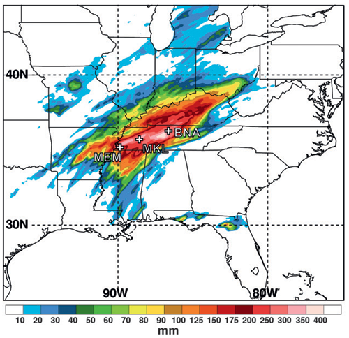
Teletraining Seminar on May 2010 Floods in Tennessee and Kentucky
The Teletraining Seminar was hosted by Bernard Meisner, Chief of Science and Training at the NWS Southern Region, on 10 May 2012. Key findings were presented from a recently published paper (by Moore and co-authors), which examines the flooding event from a meteorological perspective. The study represents an early effort in the emerging Southeast U.S. component of HMT (HMT-SE). A primary key objective of HMT-SE is to improve understanding of the atmospheric flow patterns and the dominant key physical processes that produce extreme precipitation in the Southeast U.S. The seminar featured a detailed meteorological analysis of the flooding event that drew upon a suite of observational and numerical-model based data sources and focused on the factors most useful and relevant to NWS forecasters. This analysis identified important features in the large-scale environment and key physical processes that contributed to two consecutive days of heavy rainfall across Tennessee and Kentucky. Notable findings presented from the study include:
- Two back-to-back quasi-stationary storm systems produced nearly continuous heavy rainfall during 1–2 May 2010, leading to rainfall accumulations ranging from 4 to >16 inches and widespread flooding across Tennessee and Kentucky. In Nashville, TN, where 13.5 inches of rainfall fell, there were 11 fatalities and nearly $2 billion in damages due to flooding.
- Analysis of satellite images revealed that heavy rainfall was supported by the strong transport of a persistent and highly concentrated corridor of water vapor in the atmosphere. This water vapor corridor was rooted in the tropics and became what is known as an atmospheric river (AR); a phenomenon that is a primary focus of HMT-West research due to its major role in the production of heavy rainfall and flooding along the western coast of North America.
- Large-scale meteorological analysis combined with air flow analysis revealed that the AR developed and persisted as huge amounts of water vapor were extracted from the tropical eastern Pacific, the Caribbean Sea, and the Gulf of America. The water vapor was delivered to the rainfall region by strong southerly winds carried along the eastern coast of Mexico and a broad anticyclone centered over the subtropical North Atlantic.
- The AR was nearly stationary during 1–2 May, helping to facilitate a constant supply of water vapor and available potential energy. The AR, along with the underlying favorable conditions for convective storms across the central and southern Mississippi Valley helped produce very large local rainfall totals.
- An important factor which distinguishes this heavy rainfall event from "ordinary" heavy rainfall events is the combined persistence of key ingredients for heavy rainfall during 1–2 May 2010 afforded by a stationary AR embedded within slowly-evolving atmospheric flow pattern.