|
|
|
Contacts: Ellen Sukovich and Tom Workoff
|
|
Experiment will Retrospectively Analyze Eight Major Atmospheric River Events
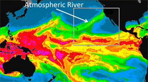
ARs are relatively narrow regions in the atmosphere that are responsible for most of the horizontal transport of water vapor outside of the tropics. While ARs come in many shapes and sizes, those that contain the largest amounts of water vapor, the strongest winds, and stall over watersheds vulnerable to flooding, can create extreme rainfall and floods. These events can disrupt travel, induce mudslides, and cause catastrophic damage to life and property.
For each case study in ARRFEX, a collaborative team of forecasters and researchers from the NCEP, NOAA research laboratories, River Forecast Centers (RFC), and Weather Forecast Offices (WFO) will be provided with both operational and experimental numerical guidance products and asked to create a variety of quantitative precipitation forecast (QPF) products, in real-time, for the eight retrospective events. Participants will also be asked to subjectively verify the forecasts and provide feedback on the performance and applicability of both the operational and experimental numerical models, datasets, and forecast products used in the forecast process. This forecaster feedback and interaction is critical for identifying biases, strengths, weaknesses, and utilities of each of the different guidance and forecast products used in the experiment.
Improved forecast guidance of ARs is critical to many west coast communities and decision makers (e.g., flood control, emergency management, water supply, reservoir operations, and transportation) and serves to help mitigate the risks of major flood events and protect life, property and the economy.