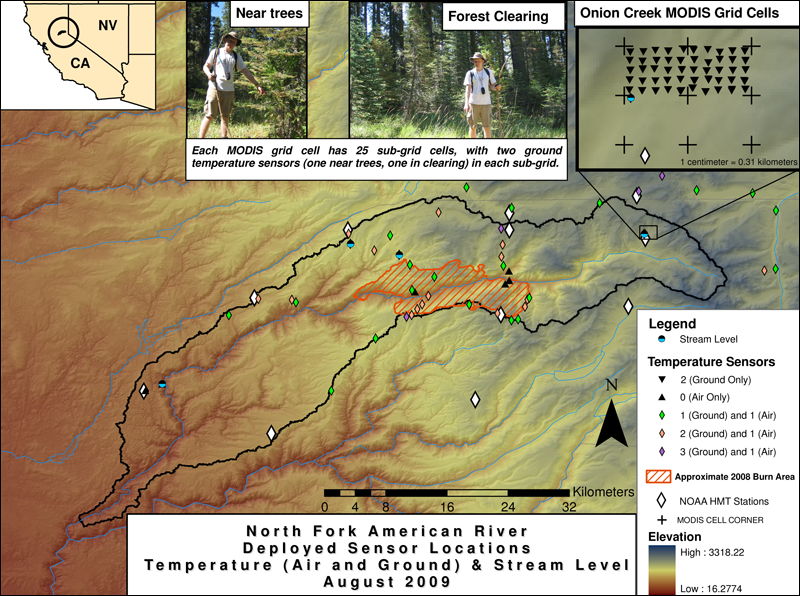
Figure 1: Locations of sensors deployed in August 2009 (click to enlarge).
|
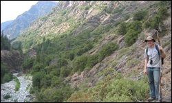
Figure 2: University of Washington Ph.D. Student Mark Raleigh in the N.F. American River Canyon.
|
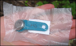
Figure 3: I-button temperature sensor, with hand for scale. This sensor is protected in plastic wrap for deployment in the soil.
|
Distributed Temperature Sensors in the N.F. American River Basin
Monitoring mountain meteorology is seldom easy, and most meteorological stations are located adjacent to roads to provide necessary access for heavy equipment. However, road corridors were never designed to provide a representative sample of weather across the mountain range, and in the vicinity of the N. F. American River Basin, the site chosen for NOAA's Hydrometeorology Testbed, the roads remain on ridges, traversing the basin's boundaries. As a consequence, there are very few stations within the basin (see white diamonds compared to black basin outline (Fig. 1). Also, most stations are on ridges or plateaus, with few samples on steep slopes or valleys, which make up a large portion of this canyon-like terrain (Fig. 2). Temperature can vary drastically over short-distances in such complex terrain and is not always a function of elevation (Lundquist and Cayan 2007; Lundquist et al. 2008a). Temperature also provides a dominant control over whether precipitation falls as rain or snow, and distinguishing the fraction of the basin receiving liquid precipitation is critical for predicting runoff and floods (White et al. 2002; Lundquist et al. 2008b), one of HMT's primary objectives. Therefore, a team led by University of Washington (UW) graduate student Mark Raleigh deployed small, self-recording temperature sensors, i-buttons, (Fig. 3) along two transects down into the canyon and up the other side, to test how well the traditional weather stations represent what is happening in the basin's interior. Air temperature sensors were deployed in trees to keep them above the snow and to shade them from solar radiation (Lundquist and Huggett 2008). Soil temperature sensors were deployed 10 cm beneath the soil surface. These measure a constant temperature of 0ºC whenever snow is present, providing information on the spatial variation of snow cover (Lundquist and Lott 2008).
Preliminary analysis has demonstrated that where i-button sensors were deployed adjacent to standard meteorological stations, they recorded the same temperature as the station, providing confidence in their accuracy. However, groups of sensors deployed at similar elevations but across different slopes and valleys within the basin had mean annual temperatures that varied by as much as 6ºC. UW undergraduate student Alex Fisher is currently investigating what controls these variations, how they can be predicted, and under what circumstances they may be important to the basin's hydrology.
References:
Lundquist, J. D. and D. R. Cayan, 2007. Surface temperature patterns in complex terrain: daily variations and long-term change in the central Sierra Nevada, California. J. Geophys. Res., 112, D11124, doi:10.1029/2006JD007561.
Lundquist, J. D., and B. Huggett, 2008. Evergreen trees as inexpensive radiation shields for temperature sensors, Water Resour. Res., 44, W00D04, doi:10.1029/2008WR006979.
Lundquist, J. D., and F. Lott, 2008. Using inexpensive temperature sensors to monitor the duration and heterogeneity of snow-covered areas, Water Resour. Res., 44, W00D16, doi:10.1029/2008WR007035.
Lundquist, J. D., N. Pepin, and C. Rochford, 2008a. Automated algorithm for mapping regions of cold-air pooling in complex terrain, J. Geophys. Res., 113, D22107, doi:10.1029/2008JD009879.
Lundquist, J. D., P. J. Neiman, B. Martner, A. B. White, D. J. Gottas, and F. M. Ralph, 2008b. Rain versus Snow in the Sierra Nevada, California: Comparing radar and surface observations of melting level. J. Hydrometeorology, 9, 194-211.
White, A. B., D. J. Gottas, E. T. Strem, F. M. Ralph, and P. J. Neiman, 2002. An automated brightband height detection algorithm for use with Doppler radar spectral moments. J. Atm. and Oceanic Technology, 19, 687-697.