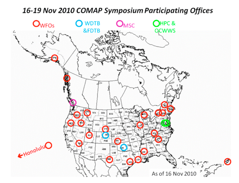
NWS offices that participated in the training
|
January 4, 2011
Training at COMET: "Intense QPF" Course Summarizes Atmospheric River Scientific Findings from HMT-West
A COMET virtual training course on "Intense QPF"
was conducted from 16-19 November 2010. As a part of this course, a summary of scientific results
from HMT-West concerning the role of atmospheric rivers (AR) in generating
extreme orographic precipitation was presented on November 18. Marty
Ralph, Chief of the Water Cycle Branch at ESRL/PSD, and Paul Neiman of PSD
summarized findings from HMT. Twenty-five attendees from the NWS and
Meteorological Service of Canada participated (see map of locations of the
offices that were represented). Unlike the recent webinars on the use of
the AR concept in forecasting presented by Dave Reynolds, the MIC at the NWS' Monterey Forecast Office,
this training was focused on the underlying scientific findings over the
last several years. The presentation described the emergence of the AR concept through
scientific papers
(show summary).
Summary of key publications describing the emergence of atmospheric rivers (ARs) as a concept and linking them to extreme precipitation on the West Coast:
- The seminal modeling paper by Zhu and Newell (1998, MWR) documented how, on average, 3-5 ARs are typically present in each hemisphere at one time, how they are related to their parent extratropical cyclones and how they contribute >90% of all midlatitude meridional water vapor transport in <10% of the Earth's circumference.
- ARs reveal themselves unambiguously in SSM/I integrated water vapor (IWV) images (Ralph et al., 2004, MWR), confirmed using NOAA P-3 research aircraft data from CALJET.
- AR conditions are conducive to creating heavy orographic precipitation (Ralph et al., 2005; MWR) and flooding (Ralph et al., 2006; GRL). Key factors include moist neutral stratification offshore (Ralph et al., 2005), strong onshore flow in the orographic "controlling layer" at roughly 1 km MSL (Neiman et al., 2002; MWR), and the existence of a shallow, efficient and common rainfall process called "non bright-band" rain that is difficult for NEXRAD to detect and for models to represent (White et al., 2003, Martner et al., 2008, Jankov et al., 2009; all JHM, and Neiman et al., 2005, MWR).
- A compositing of SSM/I AR observations in 8 years of events was carried out, and confirmation was demonstrated through NCEP-NCAR Reanalysis that the AR patterns recognized in SSM/I IWV also correspond to strong horizontal water vapor transport (Neiman et al., 2008; JHM).
- Anomalously high snow levels in ARs play a significant role in generating a major flood in the Pacific Northwest in 2006 (Neiman et al., 2008; MWR).
- Atmospheric river observatories are being developed that use wind profilers, GPS met, surface met, rapid update mesoscale model forecasts, and scientifically based thresholds on IWV and upslope wind speed to provide real-time monitoring of AR conditions (Neiman et al., 2009; J. Water Mgt.).
- Several factors contribute to the potential of individual ARs to produce extreme precipitation, including direct advection of tropical water vapor into ARs, mesoscale and frontal waves lengthening the duration of AR conditions (Ralph et al., 2011; MWR).
- Examples were offered of the presence of AR conditions connected to the tropics associated with the catastrophic flooding in Tennessee in May 2010, and with the "Snowmageddon" storm of 5-6 February 2010 that caused the heaviest snow in Washington, DC that winter.
The sessions were recorded for future use in online
learning, virtual courses, and seasonal on-station training. References are available
on the HMT Publications page.
Contacts: Marty Ralph and Matt Kelsch