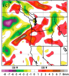
Figure 14c from Paper: Analysis of IWV (mm) in the cycling assimilation experiment at 1200 UTC 6 Nov 2006, when GPS RO soundings are assimilated with nonlocal operator. Difference fields of IWV (mm) NLOC – CTRL in the cycling assimilation experiments at 1200 UTC 6 Nov 2006.
|
|
Contact: Ellen Sukovich
|
HMT Publication Notice
HMT-West's efforts on extreme QPF includes partnering with satellite efforts, such as PMM and COSMIC. In the case of COSMIC, its ability to retrieve vertical profile information for water vapor over the ocean motivated a collaboration that brought together developers of data assimilation methods relevant to COSMIC, with HMT researchers to evaluate the potential impacts of COSMIC data on NWP associated with a well-documented strong AR that impacted the Pacific Northwest in 2006. This publication builds on an earlier article (Neiman et al. 2008 JHM) that explored the impact of COSMIC data on GFS and ECMWF analyses, where improvements of roughly 0.5 - 1 g/kg water vapor mixing ratio in the lower troposphere in an AR was achieved. These results have been incorporated in programmatic analyses related to decisions about future satellite investments. In short, COSMIC appears to be of benefit to west coast forecasting of AR conditions that are responsible for extreme precipitation and flooding.
This paper uses a case study to explore the potential of Constellation Observing System for Meteorology, Ionosphere, and Climate (COSMIC) and Challenging Minisatellite Payload (CHAMP) global positioning system (GPS) radio occultation (RO) satellite data over the eastern Pacific Ocean to improve analyses and mesoscale forecasts of landfalling atmospheric rivers (ARs) along the U.S. West Coast. It found that the assimilation of COSMIC satellite water vapor data (i.e., the GPS occultation method, which includes information on the water vapor vertical profile) provides a better mesoscale forecast in a strong AR case. Specifically it appears that the assimilation helped shift the position of the AR laterally from the first guess to a more realistic position relative to the observed SSM/I IWV signature. This was accomplished using a specialized data assimilation method developed as part of the COSMIC program in collaboration with HMT.