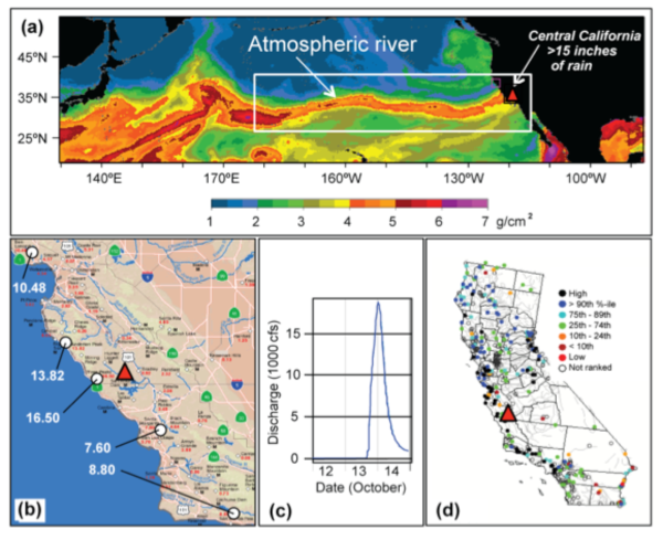
Figure 1. The October 2009 AR: (a) Satellite image from 13-14 Oct showing AR hitting coast; (b) ALERT raingage data showing 24-hour totals; (c) Discharge for Nacimiento Creek (site indicated by red triangles in other panels); (d) statewide streamflow historical ranking of October 14, 2009, compared to discharges recorded on all other October 14's.
|
|
Contact: Marty Ralph
|
HMT Publication Notice
Research during the past decade has documented the importance of atmospheric rivers (ARs) to the overall workings of the midlatitude global water cycle and in terms of extreme precipitation and flooding in areas where these features encounter mountains. Much of this work has been motivated by the requirements associated with HMT, and results have informed the development and prototyping of new monitoring and prediction tools and methods. A number of major projects have been established for which the HMT-related research on atmospheric rivers was a major driver, each of which is briefly described in the EOS article: Enhanced Flood Response and Emergency Preparedness/HMT-West Legacy Project (EFREP; led by CA Dept. of Water Resources, NOAA and Scripps Institution of Oceanography), CalWater (led by California Energy Commission, NOAA, and Scripps), ARkStorm (led by USGS Multihazards Program), Rapid Response to the Howard Hanson Dam Crisis (led by NOAA and the Army Corps of Engineers), Winter Storms and Pacific Atmospheric Rivers (WISPAR; joint between NASA, NOAA, and Northrup Grumman).
The EOS article highlights a recent extreme case where an AR made landfall on the west coast of California and led to extreme precipitation as the AR was forced up and over coastal mountains. This event produced more than 410 mm (16.5 inches) of rainfall at one site in coastal California on 14-15 October 2009 (Fig. 1). This particular AR had a very long fetch spanning most of the North Pacific (Fig. 1a), and upon making landfall deposited >200 mm of rain along a several-hundred-km-wide swath of coastal California (Fig. 1b). Significant stream flow resulted, including a roughly 525 m3/s (18,600-cfs) crest and 5-m rise in water level during 12 h on Nacimiento River (Fig. 1c), along with record high daily stream flows (for that date) at many stations in central and northern California (Fig 1d). It should be noted that this peak flow exceeded the annual peak flow (instantaneous) of 28 of the past 40 years, and did so in spite of the very dry conditions preceding this storm. This event exhibits key attributes found in other extreme ARs (e.g. Neiman et al. 2008; Ralph et al. 2011), including very large IWV values, indications of entrainment of tropical water vapor (from the western Pacific in this case, incorporating remnants of a west Pacific typhoon), and the fact that it stalled over parts of the west coast (not shown) in ways that amplified the storm impacts.