Figure 1 from the paper.

Figure 5 from the paper.
Click images for more details
|
|
Contact: Allen White
|
HMT Publication Notice
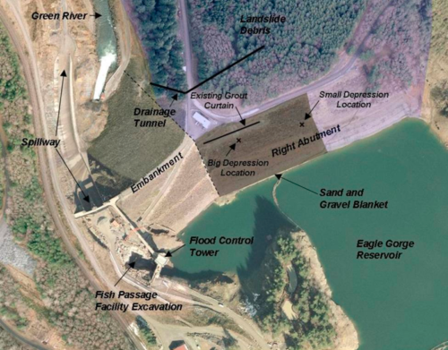
After nearly 50 years of service providing flood risk management for areas near Seattle, the U.S. Army Corps of Engineers (USACE) discovered signs of a potential dam failure at Howard A. Hanson Dam after a potent winter storm in early January 2009. This dam safety issue increased the risk of catastrophic flooding in the now highly developed Green River Valley downstream. As part of a broad set of actions by local, state, and federal agencies, NOAA implemented a rapid response effort, coordinated between its National Weather Service (NWS) and Office of Oceanic and Atmospheric Resarch (OAR), to enhance services to the communities at risk. These enhancements drew from ideas developed at NWS offices with inputs from regional stakeholders and took advantage of innovations in science and technology from HMT.
Based on success in HMT, OAR's Earth System Research Laboratory (ESRL) provided atmospheric river observatories at the coast and near the dam to give forecasters direct information on how well numerical model forecasts were capturing the atmospheric forcings associated with atmospheric rivers. In addition, the domain of the HMT numerical model forecasts was expanded northward so that the atmospheric river water vapor flux tool could be implemented in western Washington.
USACE personnel were able to begin utilizing data in decision-making by the time a storm hit the area in mid-January 2010. "We were right on the edge of taking over Wynoochee Dam today for flood risk management," said Larry Schick, a meteorologist with the USACE in Seattle, "but we had high confidence we didn't need to with the ARO info that the rain would taper off quickly – and it did."
The immediate impacts of the overall NOAA response were: (1) to allow the NWS to provide much improved flood watch and warnings for the Green River Valley; (2) to improve and strengthen the ties between NOAA and key stakeholders and recognition for NOAA's capabilities; (3) to demonstrate the responsiveness of NOAA to the Washington Congressional delegation by showing a rapid and coordinated response to provide enhanced services for their constituents; and (4) to reduce the high level of concern in the local communities in the Green River Valley.
In September 2011, the USACE announced that the Howard A. Hanson Dam could be operated to its full design capacity. Repairs to the dam and additional stabilization efforts are still works in progress. The USACE reports that drainage-improvement work is expected to be finished in October 2011. Projects for 2012 include protecting spillways from debris and reinforcing them. A detailed study of the dam's safety is scheduled to be completed by the end of 2013.