HMT Publication Notice
February 15, 2013
A journal article entitled Measurements of heavy convective rainfall in presence of hail in flood-prone areas using an X-band polarimetric radar by S. Y. Matrosov, R. Cifelli, and D. Gochis was recently published in the February 2013 issue of the Journal of Applied Meteorology and Climatology.
Radar observations are an important tool for forecasters to assess the potential of flash flooding. These observations are especially important in areas that of steep terrain where the runoff response time to precipitation is short and forecasters have little time to warn the public of an impending threat. For During the warm season, precipitation resulting from convection often occurs as a mixture of rain (liquid) and hail (ice). While hail detection is needed for short-term forecasts (nowcasts) of severe weather, assessment of instantaneous rain rates and accumulations is essential because rainfall runoff can cause flash flooding while hail is often not an immediate flood hazard since it takes time for hailstones to melt. Novel radar technologies utilizing measurements of differential phase between horizontally and vertically polarized radar echo returns allow independent estimates of the liquid component of rain and hail mixtures. To test these technologies the NOAA HMT X-band transportable radar was deployed at a site located at about 30 km from the Fourmile Canyon area, which covers approximately 24 square kilometers within the Rocky Mountain Foothills region west of Boulder, CO. A wildfire occurred in this area previously, and the radar deployment was part of collaborative research effort by NOAA, the National Center for Atmospheric Research (NCAR), and the U.S. Geological Survey (USGS) to study land fire impacts on rainfall runoff, soil erosion and debris flow.
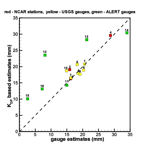
A heavy convective cell producing rain mixed with hail was observed over the Fourmile Canyon study area on July 14, 2011. The precipitation event lasted about an hour and produced significant rainfall which caused local flooding and debris flows. The figure below shows comparisons of liquid precipitation accumulations inferred using differential phase from the HMT X-band radar measurements compared to the surface precipitation data obtained from calibrated surface stations from NCAR (red symbols) and USGS (yellow symbols) as well as from several operational Automated Local Evaluation in Real Time (ALERT) gauges (green symbols). These gauges are spread across the Fourmile Canyon burn area at a range of elevations. The results show that the radar differential phase based estimates are in good agreement with the gauges, indicating that the radar captures the spatial distribution of liquid precipitation in this environmentally sensitive area. In contrast, the data from the operational WSR-88D radar data from the KFTG Denver radar located about 70 km from the burn area were not able to reproduce spatial distribution and amounts of rainfall. The results of this study indicated a value of transportable polarimetric gap filling radars for monitoring precipitation in sensitive areas.
Contact: Sergey Matrosov
Matrosov, S.Y., R. Cifelli, and D. Gochis, 2013: Measurements of Heavy Convective Rainfall in the Presence of Hail in Flood-Prone Areas Using an X-Band Polarimetric Radar. J. Appl. Meteor. Climatol., 52, 395–407, doi:10.1175/JAMC-D-12-052.1,